


ATTACCANUVPUNTI
Associa i file di nuvola di punti al disegno corrente.

Icona: 
Metodo
Selezionare un file o una cartella, specificare il nome dei dati della Nuvola di Punti, immettere un'unità per la coordinata del punto e quindi collegarla dalla finestra di dialogo Attacca Nuvola di Punti.
Il file o la cartella della nuvola di punti viene pre-elaborato in background per creare una voce della cache e quando è pronto viene visualizzato un messaggio a fumetto.
Note: Quando si selezionano nuovamente gli stessi dati di origine per i quali è già disponibile la cache, questo viene rilevato e la nuvola di punti viene inserita direttamente nel file dwg senza una nuova pre-elaborazione.
Note: La variabile di sistema POINTCLOUDCACHEFOLDER definisce la cartella in cui sono memorizzati i dati della nuvola di punti.
Note: Quando la variabile di sistema POINTCLOUDHSPC è impostata su ON, il file viene inserito nel formato HSPC.
Note: Quando un file LAS/LAZ contiene dati di classificazione, questi vengono visualizzati nel pannello Gestore Nuvola di Punti. La visibilità dei punti classificati può essere attivata o disattivata per classe. Queste informazioni saranno disponibili solo se la nuvola di punti è stata pre-elaborata in formato HSPC.
Opzioni all'interno del comando
- File
- Apre la finestra di dialogo Pre-elaborazione file(s) di dati della nuvola di punti in cui è necessario selezionare un file di nuvola di punti da associare.
Note: È possibile importare un file di nuvola di punti ASCII di quasi tutte le estensioni, con un separatore personalizzato o una distribuzione di dati personalizzata tra le colonne. Quando viene selezionato un formato di file non supportato (estensioni diverse da *.e57, *.ptx, *.pts, *.las/z, *.rcp/s, *.hspc), è possibile definire la modalità di memorizzazione dei dati punto nel file accedendo alle opzioni della Barra dei comandi o al pannello Contesto Comando Formato File Personalizzato della Nuvola di Punti. Per poter selezionare un formato di file non supportato, selezionare tutti i file (*) nella finestra di dialogo Apri file/cartella.
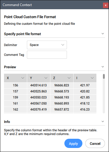
- Specificare il formato del file di punti
- Definisce del formato personalizzato per il file nuvola di punti
- Delimitatore
- Imposta un delimitatore dall'elenco a discesa.
- Tag dei commenti
- Definisce un tag di commento. Qualsiasi contenuto dopo questo tag nella stessa riga viene ignorato.
- Anteprima
- Visualizza un'anteprima del file di punti. È possibile configurare il formato della colonna.
- CArtella
- Apre la finestra di dialogo Scegli cartella di input in cui è necessario selezionare una cartella da importare.
- Commuta ignoramento geotag (ora utilizzati)
- Attiva/disattiva l'opzione ignora i geotag, disponibile nella Barra dei comandi quando la variabile di sistema POINTCLOUDIGNOREGEOTAGS è impostata su 0.