GISIMPORT command
Imports vector geographic features with their original location, shape and attributes from Shape files.

Icon: 
Description
Allows you to import vector geographic features with their original location, shape and attributes from SHP files into the current drawing and specify properties for each imported GIS Feature (Layer).
Method
Select the SHP files in the Open ESRI Shape file dialog box.
The SHP files to import are displayed in the GIS import dialog box, where you can modify their properties, such as drawing layer, GIS Data, elevation and import area.
- GIS Features are imported in the drawing as CAD entities: Points, Lines, Polylines.
- GIS Features are imported on specified Drawing Layers.
- Only GIS Features inside the specified area are imported in a drawing.
- ESRI Shape files Geodatabase format are supported.
The GIS Import dialog box allows you to import different GIS Features (Layers) with shapes and attributes from SHP files into the current drawing. You can also specify properties for each imported Feature.
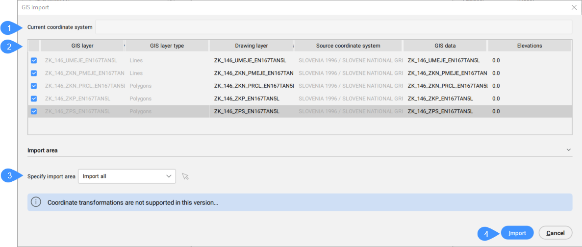
- Current Coordinate System
- Table of imported GIS layers
- Specify Import Area
- Import
Current Coordinate System
Reports the GIS coordinate system being used by the current drawing.
Table of imported GIS Features
Lists the GIS Layers to import and allows you to define their properties.
- Selected
- Allows you to select/deselect GIS features to import.
- GIS layer
- Specifies the name of the GIS layer.
- GIS layer type
- Specifies the layer type, for example lines, polygons, points, etc.
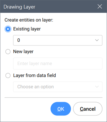
- Drawing layer
- Specifies the drawing layer on which the entities are created.
Click the Drawing layer field of the GIS feature to open the Drawing Layer dialog box to set the layer.
- Source Coordinate System
- Specifies the source coordinate system that is used in the SHP file, which is read-only.
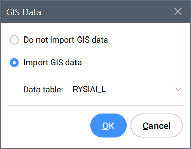
- GIS Data
- Specifies the GIS Data.
Click the GIS Data field of the GIS feature to open the GIS Data dialog box where you can choose whether or not to import the GIS data.
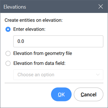
- Elevations
- Specifies the elevation at which entities are created.
Click the Elevations field of the GIS feature to open the Elevations dialog box to set the elevation.
Specify Import Area
Allows you to specify the import area.
- Import All
- Uses the entire drawing as import area.
- Select clipping polygon
-
Click the mouse icon
 to select a polygon in the drawing that defines the import area.
- Draw clipping polygon
-
Click the mouse icon
to specify an import area in the drawing.
Import
Imports the GIS features in the drawing and closes the GIS Import dialog box.