MOVEBLOCKSTOELEVATION command
Updates the Z value of a block's insertion point to match the value specified in the block attribute or in the corresponding GIS data.

Icon: 
Description
Opens the Move Blocks To Elevation dialog box that allows you to assign the Z coordinate of selected blocks according to the values defined in block attributes or GIS attributes.
- Select block name
- Select elevation from
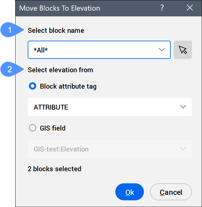
- Select block name
- Allows you to select the blocks.
The field displays the name of the selected block,
*Varies*if blocks with different names are selected, or*All*if all blocks are selected to be moved to the attribute elevation.Note:- Click the drop-down list to select the desired block name, or select
*All*to choose all blocks in the drawing. - Click the Select blocks... button (
 ) to select blocks in the drawing.
 - The number of selected blocks is displayed in the lower left corner of the dialog box.
- Click the drop-down list to select the desired block name, or select
- Select elevation from
- Allows you to select whether the block elevation is taken from the block attribute or from GIS data. Note: If you change the value of the block attribute or GIS field after the Z coordinate has already been assigned, the block elevation does not update automatically. The MOVEBLOCKSTOELEVATION command must be run again.
- Block attribute tag
- Allows you to select a block attribute tag from the drop-down list.
The block attribute value can be edited in the Attribute Editor dialog box or in the block’s Properties panel.
Note:- The numeric value assigned to the block attribute tag becomes the new Z coordinate of the block.
- Even if the selection field displays
*All*or*Varies*, only the blocks that correspond to the selected attribute tag are moved. - This option is not available if the selected blocks have no associated attributes.
- Only the block geometry is moved. To synchronize block attributes, use the ATTSYNC command.
- GIS field
- Allows you to select a GIS filed (attribute) from the drop-down list. Note: You can create and edit GIS Layers and fields in the Civil Explorer panel on the GIS Tab. The geometry type of the GIS Layer must be Point in order to attach it to a block.
The GIS field (attribute) value can be edited in the GIS Attributes Table dialog box or in the block’s Properties panel.
Note:- When the GIS field option is selected, the drop-down list displays the attributes in the format GIS Layer: Field name.
- The numeric value of the selected GIS Layer field becomes the new Z coordinate of the block.
- Even if the selection field displays
*All*or*Varies*, only the blocks that have the selected GIS fields (attributes) assigned are moved. - This option is not available if the selected blocks have no associated GIS fields (attributes).