POŁOŻENIEGEOGRAFICZNE polecenie
Umożliwia przypisanie danych lokalizacji geograficznej do pliku rysunku.

Ikona: 
Alias: GEO, NORTH, NORTHDIR
Opis
Otwiera okno dialogowe Położenie geograficzne.
Okno dialogowe Położenie geograficzne umożliwia ustawienie położenia geograficznego rysunku poprzez wybranie CRS lub ręczne dodanie współrzędnych.
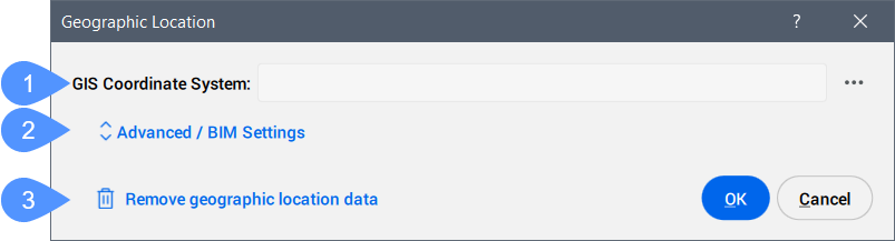
- System Współrzędnych GIS
- Zaawansowane / Ustawienia BIM
- Usunięcie danych lokalizacji geograficznej
- System Współrzędnych GIS
- Zgłasza system GIS używany przez rysunek.Uwaga: Kliknij przycisk Przeglądaj (
 ), aby zmienić układ współrzędnych GIS.
- Zaawansowane / Ustawienia BIM
- Kliknij, aby wyświetlić zaawansowane ustawienia znacznika geograficznego i kierunku północnego.
- Usunięcie danych lokalizacji geograficznej
- Usuwa dane dotyczące położenia geograficznego z rysunku.Uwaga: Położenie geograficzne jest automatycznie zapisywane na rysunku i może zostać ręcznie usunięte za pomocą tej opcji.
Zaawansowane / Ustawienia BIM
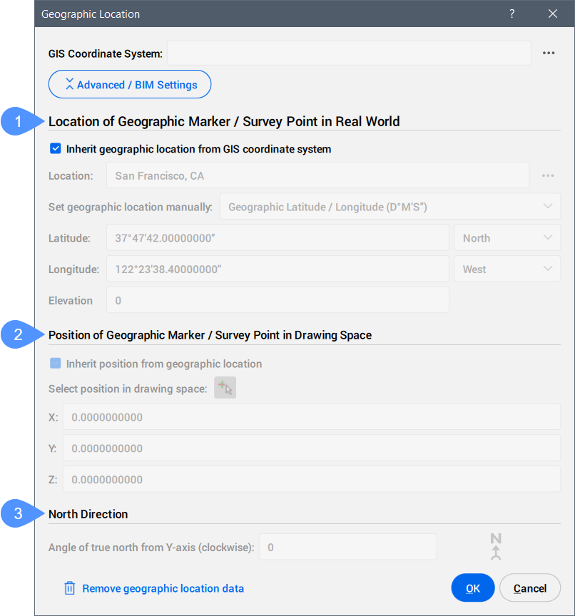
- Lokalizacja Znacznika Geograficznego / Punktu Pomiarowego W Świecie Rzeczywistym
- Pozycja Znacznika Geograficznego / Punktu Pomiarowego W Przestrzeni Rysunkowej
- Kierunek Północny
- Lokalizacja Znacznika Geograficznego / Punktu Pomiarowego W Świecie Rzeczywistym
-
Umożliwia jawne ustawienie lokalizacji znacznika geograficznego we współrzędnych świata rzeczywistego według lokalizacji lub ręcznie.
- Pozycja Znacznika Geograficznego / Punktu Pomiarowego W Przestrzeni Rysunkowej
-
Określa położenie punktu lokalizacji geograficznej na rysunku. Można je odziedziczyć z lokalizacji geograficznej lub ustawić ręcznie, wprowadzając wartości X, Y i Z.
Uwaga: Można również wybrać określony punkt w obszarze roboczym, aby ustawić pozycję.
- Kierunek Północny
-
Określa kąt słońca względem północy w kontekście światowego układu współrzędnych (kąt między prawdziwą północą a osią Y, mierzony zgodnie z ruchem wskazówek zegara).
Uwaga: Ustawienie zostanie zapisane w zmiennej systemowej NORTHDIRECTION.
Informacje o CSMAP
CSMAP to układ współrzędnych i odwzorowanie mapy, które umożliwia użytkownikom dostęp do większej liczby konwersji współrzędnych geograficznych i dokładniejszych analiz geoprzestrzennych. Układy współrzędnych są bardzo ważnym elementem mapowania lub współrzędnych geoprzestrzennych i są stale aktualizowane.
System współrzędnych CSMAP można pobrać i zainstalować na żądanie, wykonując kolejne kroki:
- Pobierz pliki układu współrzędnych CSMAP:
- Rozpakuj archiwum i skopiuj zawartość do folderu instalacyjnego Bricsys ProgramData lub BricsCAD:
- W przypadku wersji wcześniejszych niż V26: wklej zawartość do folderu instalacyjnego BricsCAD. Domyślna ścieżka to: C:\Program Files\Bricsys\BricsCAD Vxx en_US.Uwaga: Nazwa folderu musi brzmieć CoordinateSystemFiles.
- W przypadku wersji V26 i nowszych: wklej zawartość do folderu Bricsys Program Data. Domyślna ścieżka to: C:\ProgramData\Bricsys.Uwaga: Nazwa folderu musi być CoordinateSystemFiles.VersionNumber. Przykład: CoordinateSystemFiles.1500.
- W przypadku wersji wcześniejszych niż V26: wklej zawartość do folderu instalacyjnego BricsCAD. Domyślna ścieżka to: C:\Program Files\Bricsys\BricsCAD Vxx en_US.
- Uruchom ponownie stronę BricsCAD i uruchom polecenie, aby wyświetlić listę układów współrzędnych z pliku Geodatabase.xml wraz z rozszerzonymi układami współrzędnych z pobranych folderów.