SETSURVEYLOCATION command
Adds a marker for the survey location.

Description
Sets the Survey location point coordinates and angle.
Note: The Survey location point coordinates and angle will be used in RVT and IFC import and export.
Method
Add a Survey location point coordinates and angle to a new drawing or edit the Survey location point information in an existing drawing.
Pick a point in the drawing or enter the point coordinates manually and specify an angle.
Note: The default values of the point coordinates and angle in a new drawing are 0. The current values are displayed in the Command line when running the command.
Toggle On/Off the visibility of the Survey location marker by modifying the GEOMARKERVISIBILITY system variable's value (On by default).
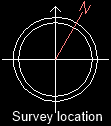
Note: The True North indicator displays the NORTHDIRECTION angle measured clockwise, stored by the NORTHDIRECTION system variable, and is the same as the Survey location angle.
Note:
- The Survey Location point corresponds to the Geographic Location point. You can find its coordinates in the Position section of the Geographic Location dialog box (see the GEOGRAPHICLOCATION command article).
- The angle value set for the Survey Location point corresponds to the NORTHDIRECTION system variable's value and represents the angle between the True North and the Y-axis, measured clockwise. Modifying the NORTHDIRECTION system variable's value changes the Survey Location angle value only if a GIS Coordinate System is set in the Geographic Location dialog box.
Options within the command
- Point
- Sets the X, Y, and Z coordinates of the point for survey location marker.
- Angle
- Sets the angle between True North and Drawing Y-axis, clockwise.
- Clear
- Clears the previously set point coordinates and angle (sets these values back to 0).