Okno dialogowe Lokalizacja geograficzna
Okno dialogowe Położenie geograficzne umożliwia ustawienie położenia geograficznego rysunku poprzez zastosowanie długości i szerokości geograficznej do punktu na rysunku.
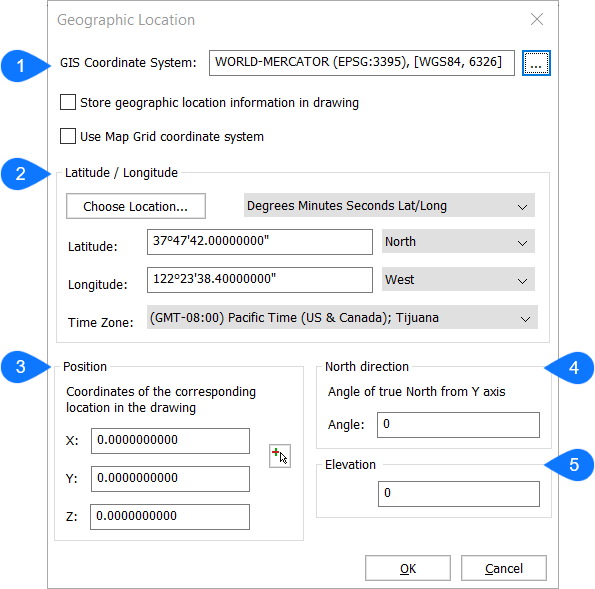
- System Współrzędnych GIS
- Szerokość / długość geograficzna
- Pozycja
- Kierunek północny
- Elewacja
System Współrzędnych GIS
Zgłasza system GIS używany przez rysunek.
Uwaga: Kliknij przycisk Przeglądaj ( ), aby zmienić układ współrzędnych GIS.
), aby zmienić układ współrzędnych GIS.- Przechowuj informację o lokalizacji geograficznej w rysunku
- Po zaznaczeniu czerwona kropka wskazuje pozycję na rysunku.
- Użyj układu współrzędnych Uchwytów Map
- Po włączeniu rysunek jest powiązany ze współrzędnymi świata rzeczywistego, danymi lokalizacji z systemu współrzędnych GIS.Uwaga: Gdy opcja ta jest wyłączona, punkt początkowy jest określany na podstawie wartości wprowadzonych dla X, Y i Z, które odpowiadają szerokości i długości geograficznej.
Szerokość / długość geograficzna
- Wybierz lokalizację
- Określa lokalizację grafiki w oknie dialogowym Wybierz lokalizację geograficzną.
- Stopnie Minuty Sekundy Dł/Szer
- Wyświetla lokalizację w formacie stopni, minut i sekund.
- Dziesiętne Dł/Szer
- Wyświetla lokalizację w formacie dziesiętnym.
- Szerokość geograficzna
- Ustawia szerokość geograficzną. Prawidłowy zakres wynosi od 0 do 90.
- Długość geograficzna
- Ustawia długość geograficzną. Prawidłowy zakres wynosi od 0 do 180.
- Strefa czasowa
-
Określa strefę czasową z listy rozwijanej Strefa czasowa.
Uwaga: To ustawienie jest zapisywane w zmiennej systemowej TIMEZONE.
Pozycja
Określa położenie lokalizacji na rysunku poprzez wprowadzenie wartości współrzędnych.
Uwaga: Można również wybrać określony punkt w obszarze roboczym, aby ustawić pozycję.
Kierunek północny
Określa kąt słońca względem północy w kontekście światowego układu współrzędnych.
Uwaga: Ustawienie zostanie zapisane w zmiennej systemowej NORTHDIRECTION.
Elewacja
Określa wysokość dla punktu długiego. Wartość może być dodatnia lub ujemna.