GISIMPORT polecenie
Importuje wektorowe obiekty geograficzne wraz z ich oryginalnym położeniem, kształtem i atrybutami z plików kształtów.

Ikona: 
Opis
Umożliwia importowanie wektorowych elementów geograficznych wraz z ich oryginalnym położeniem, kształtem i atrybutami z plików SHP do bieżącego rysunku oraz określanie właściwości dla każdego importowanego elementu (warstwy) GIS.
Metoda
Zaznacz pliki SHP w oknie dialogowym Otwórz plik kształtu ESRI .
Importowane pliki SHP są wyświetlane w oknie dialogowym importu GIS, w którym można modyfikować ich właściwości, takie jak warstwa rysunku, dane GIS, elewacja i obszar importu.
- Elementy GIS są importowane do rysunku jako elementy CAD: Punkty, Linie, Polilinie.
- Elementy GIS są importowane na określonych warstwach rysunku.
- Na rysunku importowane są tylko elementy GIS znajdujące się wewnątrz określonego obszaru.
- Obsługiwane są pliki kształtów ESRI w formacie geobazy.
Okno dialogowe GIS Import umożliwia importowanie różnych funkcji GIS (warstw) z kształtami i atrybutami z plików SHP do bieżącego rysunku. Można również określić właściwości dla każdej zaimportowanej funkcji.
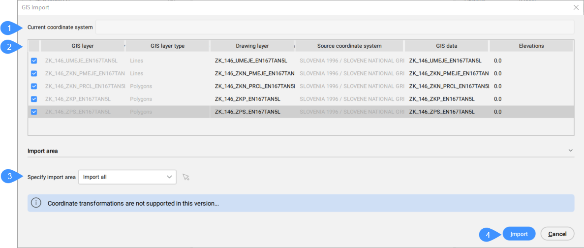
- Bieżący Układ Współrzędnych
- Tabela zaimportowanych warstw GIS
- Określ Obszar Importu:
- Import
Bieżący Układ Współrzędnych
Zgłasza układ współrzędnych GIS używany przez bieżący rysunek.
Tabela importowanych funkcji GIS
Wyświetla listę warstw GIS do zaimportowania i umożliwia zdefiniowanie ich właściwości.
- Wybrane
- Umożliwia zaznaczenie/odznaczenie funkcji GIS do zaimportowania.
- Warstwa GIS
- Określa nazwę warstwy GIS.
- Typ warstwy GIS
- Określa typ warstwy, na przykład linie, wielokąty, punkty itp.
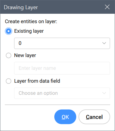
- Warstwa rysunku
- Określa warstwę rysunkową, na której tworzone są jednostki.
Kliknij pole Warstwa Rysunku funkcji GIS, aby otworzyć okno dialogowe Warstwa Rysunku w celu ustawienia warstwy.
- Źródłowy Układ Współrzędnych
- Określa źródłowy układ współrzędnych używany w pliku SHP, który jest tylko do odczytu.
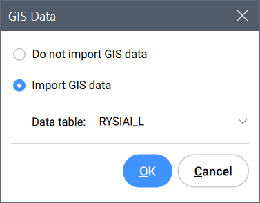
- Dane GIS
- Określa dane GIS.
Kliknij pole Dane GIS funkcji GIS, aby otworzyć okno dialogowe Dane GIS, w którym możesz wybrać, czy chcesz zaimportować dane GIS.
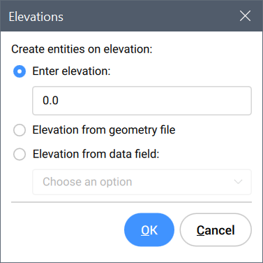
- Elewacje
- Określa wysokość, na której tworzone są podmioty.
Kliknij pole Elewacje funkcji GIS, aby otworzyć okno dialogowe Elewacje w celu ustawienia wysokości.
Określ Obszar Importu:
Umożliwia określenie obszaru importu.
- Importuj Wszystko
- Używa całego rysunku jako obszaru importu.
- Wybierz wielokąt przycinający
-
Kliknij ikonę myszy
 , aby wybrać wielokąt na rysunku, który definiuje obszar importu.
- Rysuj wielokąt przycinający
-
Kliknij ikonę myszy
, aby określić obszar importu na rysunku.
Import
Importuje elementy GIS na rysunku i zamyka okno dialogowe GIS Import.