POINTCLOUDATTACH command
Attaches point cloud files to the current drawing.

Icon: 
Method
Select a file or a folder, specify the point cloud data name and, if needed, enter a unit for point coordinates. Then, attach it from the Attach Point Cloud dialog box. See also the Attach Point Cloud dialog box article.
Note:
- The supported files types are: *.e57, *.hspc, *.las, *.laz, .lgsx, *.pack, *.pts, *.ptx, *.rcp, *.rcs, *.rdbx, *.rsp, *.zfs.
- For MacOS/Linux, the import of *.lgsx files is not yet supported.
The point cloud file or folder is preprocessed in the background to create a cache entry, and a balloon message displays when the point cloud is fully cached.
Note:
- The double-byte characters are accepted for the point cloud name.
- When the same source data is selected again for which cache is already available, this is detected and the point cloud is directly inserted in the DWG file without new preprocessing.
- The POINTCLOUDCACHEFOLDER system variable defines the folder where the point cloud data are stored.
- When the POINTCLOUDHSPC system variable is set to ON, the file is inserted in the HSPC format.
- When a LAS/LAZ file contains classification data, it is shown in the Point Cloud Manager panel. Visibility of the classified points can be toggled on or off per class. This information is only available if the point cloud is preprocessed in HSPC format.
- When geographic information is available in the original data, it is stored in the point cloud's cache (only if the point cloud is preprocessed in HSPC format). You can access this information in the Properties panel under the Misc category for a selected point cloud instance. To overwrite the DWG file's geographical information with that of the point cloud instance (possible only if the CRS of the point cloud is the same as the CRS of the DWG file), turn On the Geolocate property of the selected point cloud instance.
Options within the command
- File
- Opens the Pre-process Point Cloud Data File(s) dialog box from which to select a single point cloud file to attach. See also the Pre-process Point Cloud Data File(s) dialog box article.Note:
- The source file name is the same as the cache key and is used to check if the point cloud is available in the cache folder.
- The point cloud cache name is a user specified name for the preprocessed point cloud. It is the default point cloud name if the user does not specify a point cloud name for insertion. Multiple insertions can have the same or a different point cloud name.
Tip: You can import an ASCII point cloud file of almost any extension, with a custom separator, or a custom data distribution across the columns. When an unsupported file format is selected, you can define how the point data is stored in the file by accessing the Command line options or the Point Cloud Custom File Format command context panel. To be able to select an unsupported file format, select all files (*) in the open file/folder dialog.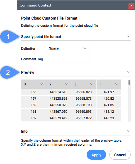
- Specify point file format (1)
- Defines the custom format for the point cloud file.
- Delimiter
- Sets a delimiter from the drop-down list.
- Comment Tag
- Defines a comment tag. Any content after this tag in the same line is ignored.
- Preview (2)
- Displays a preview of the point file. You can configure the column format.
- columnFormat
- Sets a column format.
- fOlder
- Opens the Choose Input Folder dialog box to select a folder to import.