Definicje TIN w poleceniu TIN
Przegląd
W tym artykule opisano definicje/operacje TIN, które są tworzone za pomocą metod tworzenia powierzchni TIN dostępnych w poleceniu TIN. Opisuje również okno dialogowe każdej definicji, w którym można modyfikować parametry.

Niektóre operacje, takie jak Utwórz z powierzchni, Dodaj chmury punktów i Utwórz z konturów są używane tylko do tworzenia nowej powierzchni TIN.
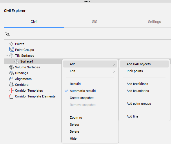
Podczas gdy inne operacje, takie jak Dodaj obiekty rysunkowe (CAD), Dodaj punkt, Dodaj grupy punktów mogą być również używane do dodawania danych do istniejącej powierzchni TIN. Dla łatwego dostępu, operacje te są również dostępne w panelu Civil Explorer (patrz rysunek poniżej).
Dodaj obiekty rysunkowe
Definicja Dodaj obiekty rysunku tworzy nową powierzchnię TIN lub modyfikuje istniejącą z wybranych obiektów rysunku/CAD.
Aby utworzyć definicję Dodaj obiekt rysunkowy:
- Użyj opcji Select entities to create TIN surface w poleceniu TIN.
- Kliknij prawym przyciskiem myszy istniejącą powierzchnię TIN w oknie Civil Eksplorator i wybierz Dodaj obiekty CAD z grupy Dodaj.
Po dwukrotnym kliknięciu istniejącej definicji Dodaj obiekty rysunkowe w zakładce Definicje panelu Civil Eksplorator, otwarte zostanie następujące okno dialogowe.
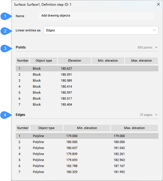
- Nazwa
- Obiekty liniowe jako
- Punkty
- Krawędzie
- Nazwa
- Wyświetla nazwę definicji powierzchni TIN: Dodaj obiekty rysunkowe.
- Obiekty liniowe jako
- Umożliwia kontrolowanie sposobu, w jaki elementy liniowe są stosowane do powierzchni TIN. Do wyboru są punkty i krawędzie.
- Punkty
- Wyświetla listę punktów dodanych do powierzchni TIN jako obiekty rysunkowe. Oprócz punktów CAD, również bloki, teksty i punkty Civil są dodawane do powierzchni TIN jako punkty. Jeśli opcja Punkty jest wybrana dla polilinii dodanych do powierzchni TIN jako obiekty rysunkowe, wierzchołki polilinii są również dodawane do powierzchni TIN jako punkty.Uwaga: Podmioty, które można dodać za pomocą opcji Dodaj Punkty to punkty, punkty Civil, linie lub polilinie.
- Krawędzie
- Zawiera listę elementów liniowych, które są stosowane do powierzchni TIN jako krawędzie trójkątów.Uwaga: Kliknij prawym przyciskiem myszy obiekt w oknie dialogowym, aby otworzyć menu kontekstowe:
- Powiększ do: Powiększa do obiektu na rysunku.
- Kopiuj do schowka: kopiuje informacje o geometrii.
- Usuń: usuwa obiekt z definicji powierzchni TIN.
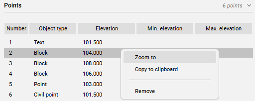
Min. i Max. wysokość: min. i maks. wysokość polilinii 3D. Jeśli min. i maks. elewacje są zgodne, to obiekt jest polilinią / polilinią 2D.
Dodaj pliki punktów
Definicja Dodaj pliki punktów tworzy powierzchnię TIN z wybranego pliku punktów.
Pozwala to na uproszczenie punktów z pliku punktów źródłowych przy jednoczesnym zachowaniu wysokiej dokładności w zdefiniowanych przez użytkownika obszarach powierzchni TIN, gdzie wymagane są dokładniejsze dane terenu.
Aby utworzyć definicję Dodaj pliki punktów:
- wybierz opcję Importuj z pliku w poleceniu TIN.
Po dwukrotnym kliknięciu tej definicji na karcie Definicje w panelu Civil Eksplorator zostanie otwarte następujące okno dialogowe.
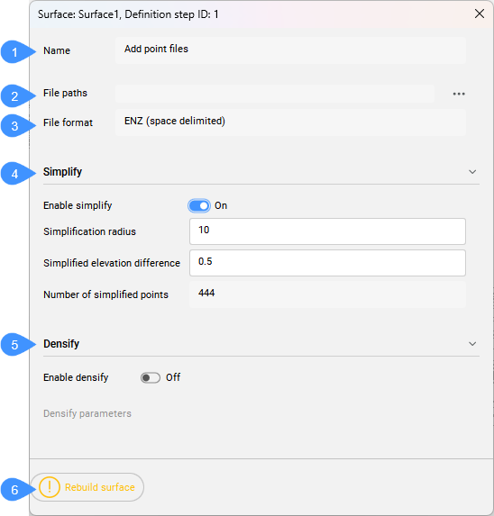
- Nazwa
- Ścieżki pliku
- Format pliku
- Uprość
- Zagęszczanie
- Odbudowa powierzchni
- Nazwa
- Wyświetla nazwę definicji powierzchni TIN: Dodaj pliki punktów.
- Ścieżki pliku
- Wyświetla ścieżkę do pliku. Naciśnij przycisk przeglądania, aby otworzyć okno dialogowe Wybierz plik powierzchni.
- Format pliku
- Wyświetla format pliku używany do importowania pliku punktów.
- Uprość
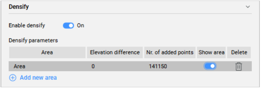
- Upraszcza powierzchnię TIN.
- Zagęszczanie
- Zagęszcza powierzchnię TIN.
- Odbudowa powierzchni
- Odbudowuje powierzchnię.
Dodaj punkt
Definicja Dodaj punkt tworzy nową powierzchnię TIN lub modyfikuje istniejącą na podstawie określonych lokalizacji i wysokości punktów TIN.
Aby utworzyć definicję Dodaj punkt:
- Wybierz opcję umieść punkty w poleceniu TIN.
- Kliknij prawym przyciskiem myszy istniejącą powierzchnię TIN w oknie Civil Eksplorer i wybierz opcję Wybierz punkty z grupy Dodaj.
Po dwukrotnym kliknięciu definicji Dodaj punkt w zakładce Definicja panelu Civil Eksplorer, otwarte zostanie następujące okno dialogowe.
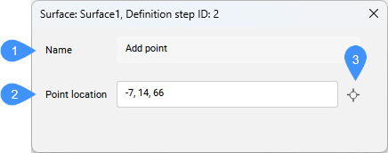
- Nazwa
- Lokalizacja punktu
- Wybierz punkt
- Nazwa
- Wyświetla nazwę definicji powierzchni TIN: Dodaj punkt.
- Lokalizacja punktu
- Wyświetla współrzędne punktu.
- Wybierz punkt
- Umożliwia wybranie nowej lokalizacji i ustawienie nowej wysokości punktu.
Twórz z powierzchni
Definicja Utwórz z powierzchni tworzy nową powierzchnię TIN z wybranych elementów 3D Face.
Aby utworzyć definicję Utwórz z powierzchni:
- wybierz opcję Utwórz z powierzchni w poleceniu TIN.
Po dwukrotnym kliknięciu tej definicji na karcie Definicje w panelu Civil Eksplorator zostanie otwarte następujące okno dialogowe.
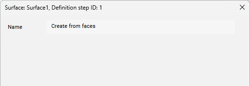
- Nazwa
- Wyświetla nazwę definicji powierzchni: Utwórz z powierzchni.
Dodaj chmury punktów
Definicja Utwórz z chmury punktów tworzy powierzchnię TIN z wybranej chmury punktów.
Pozwala to na uproszczenie punktów ze źródłowej chmury punktów przy jednoczesnym zachowaniu wysokiej precyzji w zdefiniowanych przez użytkownika obszarach powierzchni TIN, gdzie wymagane są dokładniejsze dane o terenie.
Definicje Usuń krawędzie zewnętrzne i Utwórz migawkę są automatycznie dodawane do powierzchni TIN po tej operacji.
Aby utworzyć definicję Dodaj chmurę punktów:
- wybierz opcję Utwórz z chmury punktów w poleceniu TIN.
Po dwukrotnym kliknięciu tej definicji na karcie Definicje w panelu Civil Eksplorer zostanie otwarte następujące okno dialogowe.
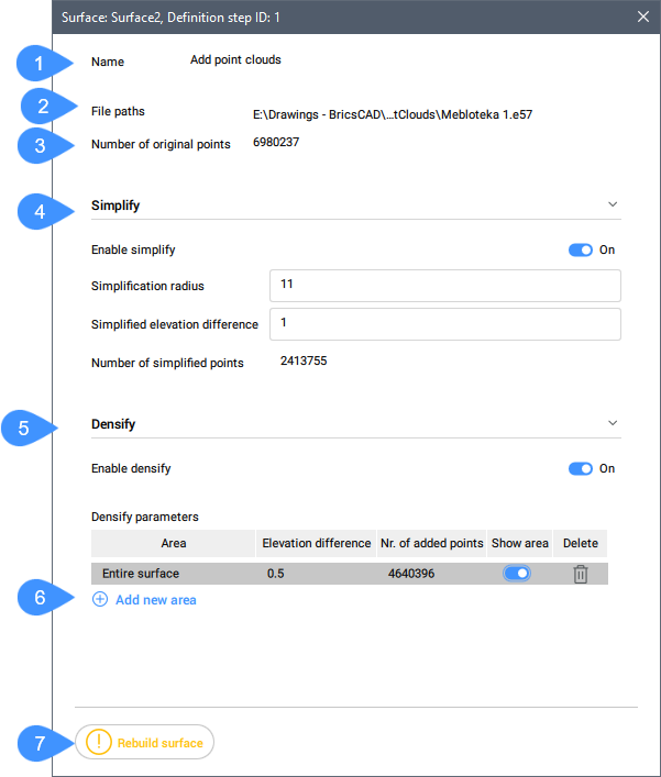
- Nazwa
- Ścieżki pliku
- Liczba oryginalnych punktów
- Uprość
- Zagęszczanie
- Dodaj nowy obszar
- Odbudowa powierzchni
- Nazwa
- Wyświetla nazwę definicji powierzchni TIN: Dodaj chmurę punktów.
- Ścieżki pliku
- Wyświetla ścieżkę pliku wejściowego.
- Liczba oryginalnych punktów
- Wyświetla liczbę oryginalnych punktów w chmurze punktów.
- Uprość
- Upraszcza powierzchnię TIN.
- Zagęszczanie
- Zagęszcza powierzchnię.
- Dodaj nowy obszar
- Dodaje nowy obszar zagęszczania. Wymaga to wprowadzenia różnicy wysokości w wierszu poleceń, a następnie wybrania istniejącego lub narysowania nowego wielokąta na rysunku.
- Odbudowa powierzchni
- Odbudowuje powierzchnię TIN.
Dodaj grupy punktów
Definicja Dodaj grupy punktów dodaje Punkty Civil z określonych Grup punktów do istniejącej powierzchni TIN lub tworzy nową powierzchnię TIN z określonych Grup punktów.
Aby utworzyć definicję Dodaj grupę punktów:
- Wybierz opcję Utwórz z grupy punktów w poleceniu TIN.
- Kliknij prawym przyciskiem myszy istniejącą powierzchnię TIN w panelu Civil Eksplorator i wybierz Dodaj grupy punktów z grupy Dodaj.
Definicja Usuń krawędzie zewnętrzne jest automatycznie dodawana do powierzchni TIN po tej operacji.
Po dwukrotnym kliknięciu tej definicji na karcie Definicje w panelu Civil Eksplorator zostanie otwarte następujące okno dialogowe.

- Nazwa
- Wyświetla nazwę definicji powierzchni: Dodaj grupy punktów.
- Grupy punktów
- Wyświetla listę grup punktów używanych do tworzenia powierzchni TIN.
Utwórz z konturów
Definicja Utwórz z konturów tworzy powierzchnię TIN z wybranych obiektów liniowych. Gęstością punktów na konturach pobranych do triangulacji można zarządzać poprzez określenie ograniczanie i uzupełniania współczynników. Gdy dane wejściowe zawierają łuki, dokładność punktu TIN wzdłuż łuków zależy od parametru Odległość środkowa.
Metoda ta automatycznie minimalizuje płaskie trójkąty poprzez zamianę krawędzi TIN.
Aby utworzyć definicję Utwórz z konturów:
- wybierz opcję Utwórz z konturów w poleceniu TIN.
Definicja Usuń krawędzie zewnętrzne jest automatycznie dodawana do powierzchni TIN po tej operacji.
Po dwukrotnym kliknięciu tej definicji na karcie Definicje w panelu Civil Eksplorator zostanie otwarte następujące okno dialogowe.
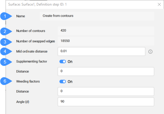
- Nazwa
- Liczba konturów
- Liczba zamienionych krawędzi
- Odległość środka cięciwy
- Czynnik uzupełniający
- Czynniki wykluczenia
- Nazwa
- Wyświetla nazwę definicji powierzchni TIN: Utwórz z konturów.
- Liczba konturów
- Wyświetla liczbę konturów.
- Liczba zamienionych krawędzi
- Wyświetla liczbę zamienionych krawędzi.
- Odległość środka cięciwy
- Dodaje dodatkowe punkty TIN wzdłuż łuku zgodnie ze środkową odległością współrzędnych, która jest używana do aproksymacji łuku.
- Czynnik uzupełniający
- Przełącza użycie czynnika uzupełniającego.
- Czynniki wykluczenia
- Przełącza użycie współczynnika wykluczenia.
Przytnij wielokątem
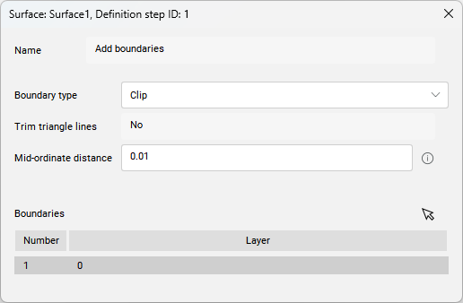
Po wybraniu opcji wytnij wielokąt w poleceniu TIN, nowa wytnij granicę zostanie dodana do powierzchni TIN jako definicja Dodaj granice.
Po dwukrotnym kliknięciu tej definicji na karcie Definicje w panelu Civil Eksplorator zostanie otwarte następujące okno dialogowe.
